Sound Transit has been busy boiling down thousands of public comments to find the best light rail route into Ballard. Even though light rail is YEARS away, the decision on the specific route — which will be Ballard’s largest development project since the Ballard Locks — will be made early next year.
At this week’s advisory board meeting, Sound Transit rated 7 routes into Ballard — some over a bridge, some through a tunnel — by 25 different criteria.
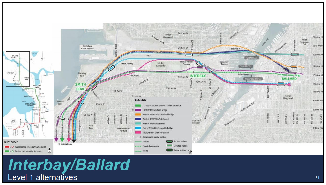
Let’s start by showing the routes (click for larger):
And the ratings for each of the routes (click for larger):
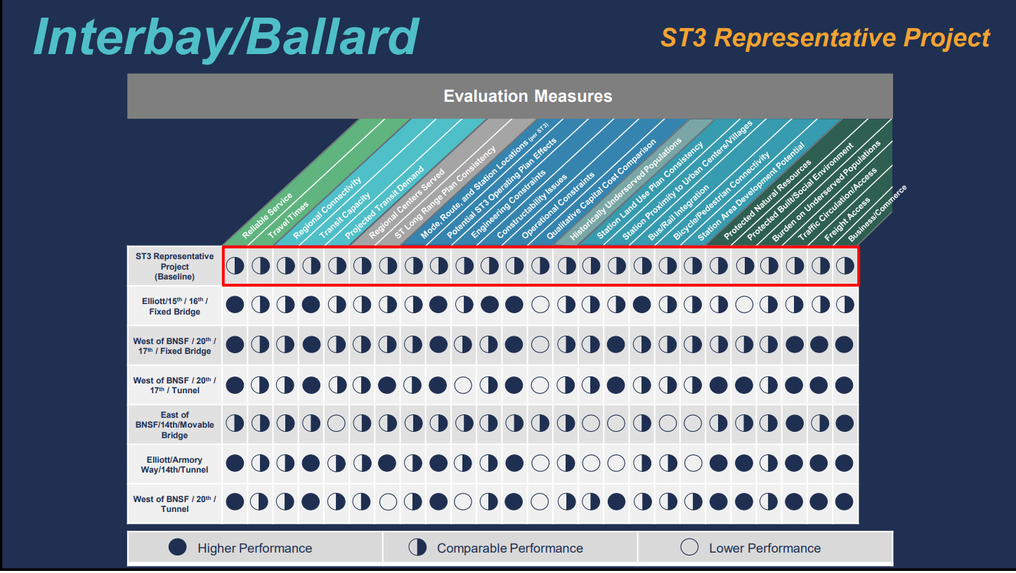
The “ST Representative Project” is Sound Transit’s initial proposed route, running down Elliott and 15th Ave. NW, traveling over Salmon Bay on a “movable bridge” (which opens for ship traffic) and moving into an elevated station at 15th and Market. As we’ve been reporting, this route has been widely controversial — mostly for traffic and business disruptions — and Sound Transit is using it as a “baseline” in the evaluation, giving it half circles across the board in the ratings.
While all of the 6 alternative routes avoid traveling down 15th Ave. north of Dravus St., they vary widely. One proposal puts the Ballard station as far west as 20th Ave. NW and Market. Another at 17th Ave. NW and Market. Two proposals have the station in the industrial area at 14th Ave. NW and NW 51st St. The proposed routes range from a fixed bridge or movable bridge to a tunnel.
In the presentation — which is available here in a .pdf deck — Sound Transit looked at each alternative, crunched the ratings and presented “alternatives with more potential” vs. “alternatives with greater challenges.” Here it is (click for larger):
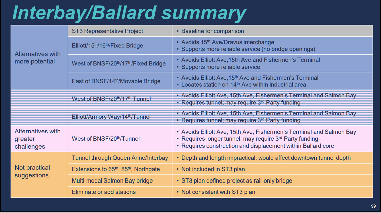
The tunnel options scored high on reliability and minimizing impact on Fishermen’s Terminal, but low on engineering constraints and costs. And that bumped them down the list, leaving the fixed bridge and movable bridge options in the top three: 1) Fixed bridge just to the west of Ballard Bridge to station at 15th and Market 2) Fixed bridge north of Fishermen’s Terminal to station at 17th and Market 3) Movable bridge a block east of Ballard Bridge to station at 14th and 51st St.
The advisory group meets next week (April 24th from 5-8 p.m.) to see which alternatives to take off the table — and which to favor. The goal is to come to a top-level recommendation they’ll forward to the leadership group and the Sound Transit Board. Then they’ll decide by early next year where Ballard’s light rail line and station will be located. For more information on the project and the timeline, visit Sound Transit here.
(Our thanks to West Seattle Blog for help on this story).

There’s an alternative with a station on *14th*? And it’s in the running?
I’m starting to think someone involved in this process owns a lot of property east of 15th. I’m not sure why else it would make sense to try to drag the neighborhood center to the border of what’s currently a residential/light industrial mix.
It’s another 30 or more years away and plans will change 10 or 20 times until then? Let’s stop spending time and money on plans until it’s closer!!
@Steven Sound Transit says it needs to decide by early next year because it takes that long to plan and build. Would hate to see lots of frustrated Ballardites who didn’t realize that decision time is quickly approaching.
Just a clarification, in your descriptions you mention “north” and “south” of Ballard bridge, as well as “as far north as 20th Ave NW” … I think you actually mean “west” and “east” of Ballard bride and “as far west as 20th Ave NW”, etc. The orientation route options map makes “up” equal to “west”, not north.
The one thing I see about options east of 15th is that there are a lot of buildings that could be re-developed into high-density housing in the next 30 years.
@KB Oh, you’re right. Fixed. Thank you!
Let’s take bets now, what’ll be finished first; the missing link of the Burke Gillman along Shilshole Ave, or the light rail to Ballard? :D
Let’s see.
UW: higher crossing point for the ship canal, lab equipment that is sensitive to vibration, public land = tunnel.
Ballard: low crossing point for the ship canal, heavy industry, private land = bridge.
ST = stupid transportation
@Damon: Public agencies are usually beholden to come up with and examine alternates, which is a good thing. The bad thing is that usually you have to come up with X amount of alternates. So in a case like LRT to Ballard, where there’s really not a lot of different routes it can take, they basically add some throw away alternates, to satisfy the quota.
So 14th won’t happen. Even if ST lost their mind and went with it, Seattle wouldn’t allow it. After the Rainier Valley debacle, Seattle has actually done well with pushing for station locations that make sense and have either existing density or potential for a lot of density surrounding the station. 14th, and it’s walkshed, is all single family homes and industrial.
The number one problem with our transit planning is highlighted by the “Not Practical Suggestions” items.
Except for the outrageous $$$ to tunnel under queen anne, the other three are all very valid issues to consider when planning transit over the next several decades.
It’s crazy that thinking about how the route may one day extend north is automatically excluded from consideration from the design. If a new bridge over this ship canal is needed in the next 30 years – why not include it in this analysis?
Let’s not be penny-wise and pound-foolish. This thing will be mega-expensive no matter what, so it should be built right. West Ballard is poorly served by transit and experiencing rapid growth (below 65th, for now, and I hope further North later). A 20th St. station is still too far East in my opinion, but better than the other options. I think it should be an underground station at 22nd, then up to Ballard High (preferably underground, but that’s unlikely).
I think you actually mean “west” and “east” of Ballard bride and “as far west as 20th Ave NW”, etc
This light rail wherever it goes will bring more human filth. People would rather drive, then put up with it.
Solution,
No more cars, except for infrastructure, like ambulances, utilities. There should be bike and walk paths separated by dividers. Car roads discriminate against feet. Pedestrians. Humans. They will bring human garbage to places where people pay a premium to be safe from human garbage.
Would the bridge designs also be able to accommodate bikes?
14th Avenue, having previously had a trolley running up the middle, is extra wide, and so has the right-of-way for a light rail line. That’s why it is being considered. When the crosstown Ballard-to-UW line is built, it will extend well west of any 14th Avenue station, so those parts of Ballard will become accessible by rail.
All good points, Foaming Solvent, but as far as I know, there is no cross-town line on the planning board, though I have suggested it as a streetcar line for a while (I still don’t understand why I’m not King!). Is there a plan for cross-town rail? Will it happen before 2050? Or will Mayor Durkin nix it? Do I sound bitter?
“Would the bridge designs also be able to accommodate bikes?”
Apparently you have been out of town.
Seattle has finally voted that bike people just are not worth the time and energy they “demand”.
Beginning 1st of July , Aurora Ave will be the only street in King County to allow any bikes to be ridden.
I think you actually mean “west” and “east” of Ballard bride and “as far west as 20th Ave NW”, etc..