
It appears that winter is finally here – at least the first snowflakes are in the forecast for Seattle. Most of the weather folks are saying the snow could be below 500 feet late Saturday/early Sunday – and possibly next week.
Cliff Mass gives a great write-up on the weather for the next few days. He summarizes with this:
So the bottom line: a very good chance of some lowland snow, but not a uniform heavy snowfall…snow in showers and potential for some accumulation in a convergence zone and the higher eastern suburbs. And with all snow forecasts, there is substantial uncertainty, although several ensemble systems and other forecasts suggest that we can have a lot of confidence in the larger scale patterns.
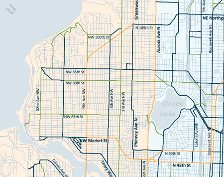
Click here for a larger version of this map (.pdf)
The Seattle Department of Transportation says they’re ready. “Throughout this week Street Maintenance crews have been treating areas prone to roadway frost and ice to improve conditions for drivers, and will continue this operation while nighttime temperatures remain low,” a release from SDOT states.
If/when it snows in Ballard, 15th Ave NW is a “level 1” arterial that will be cleared to bare and wet from curb to curb. NW Market Street through downtown Ballard is a “level 2” arterial – one lane in each direction will be treated. East of 15th Ave NW, Market Street turns into a “level 1” arterial. NW 65th, NW 80th Streets and 32nd Ave NW are a “level 3” arterials that will have curves, hills and stopping zones treated.
You can also monitor snowy conditions at the new Snowwatch website.