
Seattle Public Utilities (SPU) and King County Department of Natural Resources (DNRP) are working together to build an underground storage tunnel to reduce the amount of sewage and stormwater that discharges into the Lake Washington Ship Canal at Ballard, Fremont, Wallingford, and North Queen Anne.
The proposed 2.7 mile underground storage tunnel will capture and temporarily hold more than 15 million gallons of sewage and polluted runoff discharged in heavy rains, referred to as combined sewer overflows (CSOs). When a storm passes, CSOs will be sent to the existing King County West Point Wastewater Treatment Plant.
SPU recently prepared a long-range plan to reduce sewage overflows and stormwater runoff, referred to as The Plan to Protect Seattle’s Waterways (Plan). The Plan was evaluated in a programmatic Environmental Impact Statement (EIS) issued by SPU in May 2014 and finalized that December. The Plan, and the Draft and Final Plan EIS, can be read at www.seattle.gov/CSO.
The Ship Canal Project is one of the first projects in the Plan to be implemented. Based on review of the environmental impacts, costs, and other considerations, SPU determined that a tunnel is the preferred approach for constructing the Ship Canal Project.
Other major features of the project are summarized below:
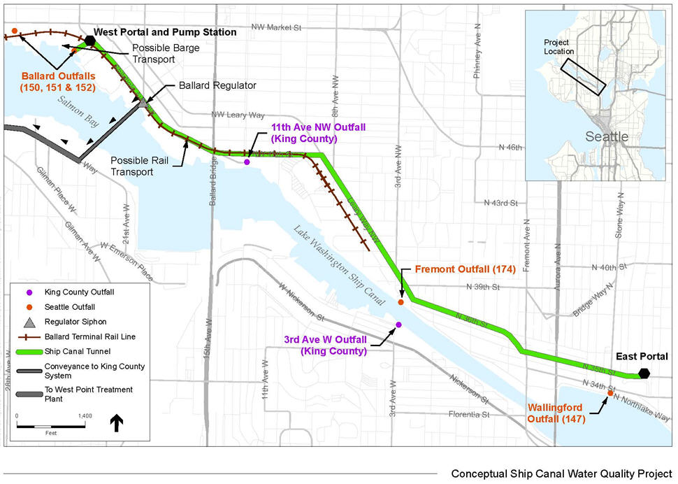
- Storage Tunnel: up to an approximately 18-foot diameter, 2.7 mile long tunnel, holding at least 15.2 million gallons (MG), largely underlying street rights-of-way along the north side of the Ship Canal. The tunnel would be located more than 100 feet below ground.
- West Portal: a structure where the tunnel boring machine would be launched and all tunnel-excavated materials (called “spoils”) would be removed. During construction, material handling facilities would be located on the portal site, an approximately 2-acre site to be acquired by the City. An adjacent existing City-owned pier will be rebuilt to transport spoils to a barge. Privately owned piers at other locations along the north side of the Ship Canal may be used as well. Construction may also include transport along an existing rail line. Following construction, the same portal used for tunnel mining will receive flows from the Ballard area, as well as house a pump station used to empty the tunnel. The above-ground, two-story pump station building will include equipment to remove grit and debris from flows entering the tunnel, an electrical motor, and instrumentation. An odor control facility and standby generator will be located outside the building within the site boundary.
- East Portal: a structure on an approximately half-acre City-owned site where the tunnel boring machine would be retrieved. Following construction, the portal will receive flows from the Wallingford area, as well as house odor control equipment and an above-ground standby generator building.
- Drop shafts: vertical structures that convey flows into the storage tunnel will be located close to existing outfalls near 11th Ave. NW in Ballard, 3rd Ave. NW in Fremont, 3rd Ave. W on the south side of the Ship Canal, and at the West and East tunnel portals. Following construction, two of the drop shafts will house odor control equipment and standby generators.
- Conveyance facilities: buried near-surface pipes to transport flows from the Ballard, Wallingford, Fremont, and North Queen Anne neighborhoods to the tunnel drop shafts. Conveyance facilities include below-ground pipes, diversion structures (e.g., weirs), and associated piping components. Approximately 3,400 lineal feet of conveyance pipes ranging from 36- to 72-inches in diameter will be constructed to bring flows to the drop shafts. These pipes will be built using a combination of open-cut and microtunnelling construction methods, largely in public rights of way. Approximately 1,900 lineal feet of dual 24-inch diameter pipes will be constructed to transfer stored flows from the tunnel to the King County wastewater treatment plant in Magnolia. Other conveyance components, including points of connection with the tunnel and/or diversion structures, will be included as needed. Surface disruption of streets and public rights of way, including the potential for loss of street parking and temporary lane closures or detours, will be required to construct many of these facilities.
- Existing infrastructure replacement and protection projects: During tunnel construction, crews may disrupt or damage existing infrastructure, particularly older sewer lines, water pipes, and other utility infrastructure. In some cases, this project presents an opportunity to proactively replace or repair aging infrastructure, combine construction projects, and reduce the number of times streets and neighborhoods would be disrupted. One such case is replacement of an existing aging outfall near the 24th Ave. NW street end.
This week’s announcement is provided by the City of Seattle’s Department of Planning and Development (DPD) as posted in the Land Use Information Bulletin.
To learn about the project, visit SPU’s project website www.seattle.gov/util/ShipCanalProject or email SPU_ShipCanalProject@Seattle.gov for additional information.
Comment by email (please include Ship Canal Project Scoping in the subject line) or by U.S. Postal Service to the SEPA Responsible Official at the address below by August 24, 2015:
Seattle Public Utilities
Attention: Betty Meyer, SEPA Responsible Official
Seattle Municipal Tower, Suite 4900
P.O. Box 34018
Seattle, WA 98124-4018
betty.meyer@seattle.gov