New markings at intersection confuse drivers

The intersection where 17th Ave NW meets NW Leary is not a traditional one. NW 48th St. also feeds in here and their have been no markings to determine the intersection, until recently.

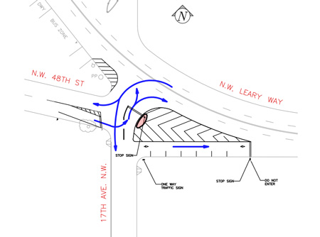
As part of the Neighborhood Street Fund program, the Seattle Department of Transportation added stop signs, markings and a small raised curb island to the intersection. “This is SDOT’s response to a Ballard District Council request to provide a low cost improvement until future bicycle master plan and pedestrian projects are implemented,” Marybeth Turner with SDOT tells us. Above is the diagram sent to us to illustrate how the intersection is intended to flow.

Several drivers we saw were confused about which way to turn off 48th. “Vehicles and trucks heading eastbound on NW 48th Street now access NW Leary Way by first turning left onto 17th Ave NW and then turning right onto NW Leary Way at the new stop sign,” Turner explains. The eastbound-only lane south of the stripes heading onto Leary is to provide access to parking stalls for local businesses. (Thanks Michael for the tip!)

Geeky Swedes

The founders of My Ballard

26 thoughts to “New markings at intersection confuse drivers”

  1. Still thinking that this intersection may benefit from a traffic light, though only if it was synchronized with the one at 15th and Leary.

  2. What is confusing about it? Stay in the right hand lane. When you turn, stay to the right. Stop at the stop sign. Don't drive in the lane with oncoming traffic. Look left, right, left. You're not in England. Stay in the right lane.

  3. Agreed, and as a pedestrian, I've been less concerned about walking through that area. It shouldn't be as confusing as it was, but, who knows what people are thinking (thinking?, I dunno if that's a fair inference…).

  4. I had been crossing at Leary & 20th instead of Leary & 17th when I head northbound because the intersection is so large. This feels like a good improvement, but time will tell. At the very least, it reduces the area of the potential conflict zone.

    As our neighborhood gets more densely populated, as these new condos all fill up, I think that we will eventually need stop lights at Leary & 17th and/or at Leary & 20th. Shilshole & 17th needs a stop light or 4-way stop too.

  5. I saw this yesterday on the way home from the Farmer's Market and thought it was terrific. Seems to make a lot of sense, but as other posters noted, time will tell.

  6. The markings are an improvement if people (and I mean drivers, peds, and bikes alike) pay attention. That intersection has always seemed to me to be a real seat belt tightener.

  7. Given the number of cars that I see peeling south off of Market St. the need is now for a real intersection, with lights and signage.
    Just south on 17th has increased ten fold in a short time.
    The traffic backs up to Swedish constantly east bound from 15th, the alternate route is 17th for southbound 15th, and 17th for northbound 15th.
    That is happening, without any overt rerouting, and the condos/apartments in the area have yet to fill up.

  8. Would anyone be interested in doing some traffic counts?

    It isn't too hard, it just takes time.
    Here is one of the traffic maps from 2006:
    http://www.cityofseattle.net/transportation/ima

    Say from 6am – 10am or 4pm to 8pm on a weekday, take it in 15 minute segments. Ideally, bicycles in one colum, trucks in another, cars in another, pedestrians in another. Count northbound vs. southbound.

    Or, if you can cover a whole intersection, north-straight, north-right, north-left, east-straight, east-right, east-left, etc. For something like 17th & market you'd want a few people, each covering a different set of movements.

    SDOT can then plug that data in to traffic simulation models and/or compare that data to historic data to make better decisions. It seems like one really great thing we could do as a community to help with traffic planning is to give SDOT some really nice granular data about how traffic is flowing in our neighborhood.

  9. Let's get some of those sq. foot gray boxes that they used to use, you know, the ones that were attached to a rubber hose stretched across the traffic lane.
    Those could yield all the data required, especially when used for specific lane uses.
    From what I recall, the numbers were clearly visible. Anyone could drive up, bike up, walk up to the box and disseminate the data.
    I'd hazard a guess that a lot of east bound Leary is favoring the quickest right lane possible, for south 15th.
    The rest are going to church ;-)

  10. Speaking of taking the left from Market to Leary southbound, what does it take to get that turn further restricted? 6pm is not late enough (not that people respect that sign anyway). Left turns should be restricted until at least 7:30pm. There is just too much traffic flow in the evenings, and Market westbound really gets screwed by people sitting in the left lane waiting to turn. Add some pedestrians crossing while someone waits to turn right, and you can have traffic sitting for 2 or 3 light cycles.

  11. From Market, northbound on 17th could also be either going to church or going to get coffee from scantily clad women. …so, saints or sinners. ;)

    Eastbound on Leary, my impression is that 1/3rd is headed south across the Fremont Bridge and into the S.Lake Union area, and 1/3rd is avoiding 45th and trying to get to I-5, the U-district, or I-520.

    The nice thing about in-person counts instead of using the boxes is that you can get bike & ped, and car vs. truck data too. It is also able to provide turning data to build a picture of where people are coming from and where they are going. I don't think the boxes are able to give turning data, they just give total # of vehicles.

  12. Yep, but until the walk signals are staggered, meaning that they stay don't walk for the time the left lane can be cleared, you'll see no releif.

  13. I don't know what disturbs me more:
    1) That an intersection was designed this way in the fist place.
    -OR-
    2) That people who find this confusing are allowed to drive a car. Honestly, if you're challenged by this intersection are you really competent enough to be behind the wheel of a 3000 pound killing machine hurtling down the road?

  14. Thanks to those who kept pushing the city to implement the plan for this intersection, first called for in the South Ballard Transporation Corridor Study (i tried to pull the link from SDOT, but it's no longer there..)

    This was a ped nightmare, and with 17th designated as a bicycle boulevard, channeling motor vehicles as done is a boon for all modes moving through here (actually, us cyclists get a little pinched in the outside lane coming around the corner, compared to the wide sweep of safety you could take before) – but this is good, real good.

    Thanks SDOT, finally!!!

Leave a Reply