
Want to take a stroll around Ballard? The Seattle Department of Transportation has a new recreational walking map to help you figure out the best route for your interests and your fitness level.
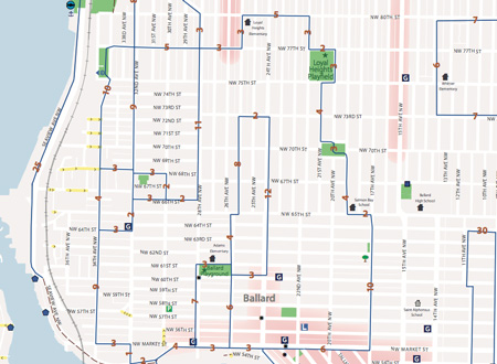
The map gives an estimated time along each leg of a walk. For instance, to walk from Market to NW 65th along 17th Ave NW, the map predicts it will take about ten minutes. As Seattle residents know — and as visitors quickly pick up — city streets vary in slope from pancake flat to whoo-boy steep. Those streets are colored yellow on the map. Thankfully Ballard is fairly flat.
The routes on the Seattle Walking Map come from a variety of sources, including The Feet First walking advocacy organization, King County, and SDOT. Routes follow sidewalks, shoulders on quiet streets, and park trails.
This new series of maps divides Seattle into three sections: north, central, and south. Adjoining sections of the map include a limited amount of overlap, should the selected route cross from one section to another. The entire city map can be found here (.pdf) with the North Seattle map here (.pdf).